 Algar is a pueblo blanco of approximately 1800 inhabitants, situated near to the Embalse (reservoir) de Guadalcin and about 65 kms south west of Olvera, roughly 90 minutes drive.
We arrived at 11 am after a pleasant drive through the scenic countryside and parked next to the Plaza de Toros (Bullring).

This fountain was undergoing maintenance and re-painting. There was a plaque explaining the significance of the galleon but unfortunately it was barely readable due to the plastic covering being a bit opaque with age. I can only think it may be related to the founder of the town in 1773, Domingo Lopez de Carvajal who, after surviving a violent storm at sea vowed to found a settlement deep in the mountains of Cadiz. Hence, Santa Maria de Guadalupe, subsequently renamed Algar, was founded.


As always we headed uphill intending to find a tourist office or the Ayuntamiento, where hopefully we could pick up a map with some information on the town.


We came across this little girl presumably with her abuelo (grandfather), blowing bubbles in the street.
 After a short while we arrived at the Plaza de la Constitución. Pictured here is the Casa Consistorial (Town Hall).
 In the centre of the Plaza was a monument dedicated to all the emigrants who had left Algar for other parts of Spain and also to France, Germany and Argentina. The town celebrates the event with the "Fiesta del Emigrante" in August.
 Opposite the Town Hall, on the other side of the Plaza, was the 18th century Iglesia de Santa Maria de Guadalupe.
 These ladies were painting their house in preparation for the Fiesta of the town's patron saint, Santa Maria de Guadalupe, that starts within the next couple of days.
 The Bullring.
 A translation of this tiled plaque on the wall of the Bullring celebrates the day in 1998 when the bull named "Despedido" was considered to be so brave and noble that the Matador Juan Contreras of El Bosque and the judges declared that it's life be spared. This was considered a great honour for the breeders, the brothers Vergara from Caceres and the bull was returned to the herd for breeding, thereby increasing the value of their stock. (information and translation kindly supplied by our good friend Dan).


 After a coffee and coke at a restaurant across the road from the Bullring, we headed out of town to find the Embalse.
We cannot say that Algar is the prettiest town that we have been to but it was certainly clean and very friendly.
 We drove south out of the town on the A-2201, heading towards San José del Valle, which in the absence of any signage looked the best way to go.
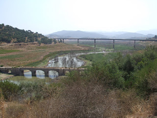
After about twenty or so minutes we came to the area where the reservoir should have been. However, due to the hot spell of weather over the past couple of months, the water had receeded dramatically.
The bridge in the foreground would normally be submerged. In the background and pictured below is the road bridge that crosses the reservoir.

The bridge in the foreground would normally be submerged. In the background and pictured below is the road bridge that crosses the reservoir.

We did drive on for a further 10kms or so and we could see water, a lot of it, on our right hand side. However, we couldn't see any access road(s) so we turned round and headed home.


No comments:
Post a Comment